Arizona State University CAMPUSES     STUDENTS     FACULTY & STAFF     ALUMNI     VISITORS & FRIENDS   

A-Z Index      Calendar      Catalogs      Degrees      Directory      eServices      Give to ASU      Maps      myASU   

Home > Features > Mineral Map of a Mars Landscape

First Mineral Map of a Mars Landscape

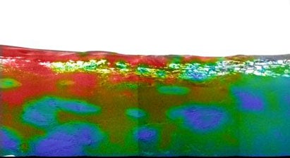
Spectacular images of Mars in infrared were taken by the Mini-TES instrument on the Opportunity Rover, directed by ASU geologist Philip Christensen. The colors indicate relative quantities of the important mineral hematite -- the red areas are high in hematite, the blue and green areas are low. The bounce marks left by the lander's balloons are blue or green, indicating that the balloons pushed the hematite into the underlying dust. Christensen's image is the first on-site mineral map ever made on Mars, and gives mission scientists critical information they need to study the site.

Image taken by the Mini-TES instrument on the Opportunity Rover
Image Credit: NASA/JPL/Arizona State University/Cornell

For more information on how Mini-TES works read “That’s a Mars of a different color – a new technology from ASU unlocks planetary secrets”


More images: http://www.jpl.nasa.gov/mer2004/


For more information, contact James Hathaway, 480-965-6375 or Hathaway@asu.edu


Read More:

• Mini-Thermal Emission Spectrometer (Mini-TES)
• "That's a Mars of a different color - a new technology from ASU unlocks planetary secrets"
• More images: www.jpl.nasa.gov/mer2004/


  Invest in ASU  |   Accessibility |  Contact ASU |  Privacy   

Copyright and Trademark Statement   


1-480-965-9011