Portfolio: Glaciers
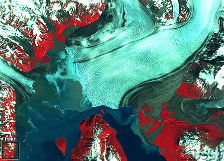
Hubbard Glacier, Alaska 1985-1986
Rollover the image to see glacial movement.
These images show the vicinity of Yakutat Bay, Alaska. Russell Fiord is the narrow body of saltwater connected to the bay and extending southeast. The Hubbard Glacier lies where Russell Fiord meets the bay.
In May 1986, the Hubbard Glacier surged down from the mountains, blocking the outlet of Russell Fiord and creating "Russell Lake". All that summer the new lake filled with runoff; its water level rose 25 meters, and the decrease in salinity threatened its sea life. Around midnight on October 8th the dam began to give way. In the next 24 hours an estimated 5.3 billion cubic meters of water gushed through the gap, and the fiord was reconnected to the ocean at its previous level.
The fiord could become dammed again, and perhaps permanently. If this happens, the fiord could overflow its southern banks and drain through the Situk River instead, threatening trout habitat and a local airport.
Thanks to the USGS for the two images used to create the rollover above. For more details and images go to http://edcwww.cr.usgs.gov/earthshots/slow/tableofcontents
![]()