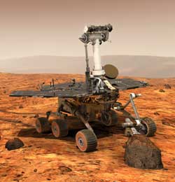
On Saturday, January 24, at 10:05pm Arizona time, the Opportunity
Rover, the second of NASA’s twin Mars Exploration Rovers
(MER), landed on a very interesting part of Mars known as Meridiani
Planum. A crowd of about 500 onlookers cheered as NASA executed
a flawless landing in what turned out to be a small, shallow crater
in an exotic gray plain, with weathered rock outcroppings. Arizona
State University scientists watched it all unfold with anxiety,
anticipation, jubilation and a great deal of personal and professional
interest.
Meridiani Planum is literally on the opposite side of Mars from
Gusev Crater, where the first rover, Spirit is currently picking
its way across a flat, ochre-colored, dust and rock covered landscape.
Opportunity, ASU scientists hope, is about to explore a landscape
that is significantly different, especially when you look at it
in infrared light.
Meridiani Planum is a plain in the middle of Mars’ Terra
Meridiani region, an area of Mars that has long intrigued planetary
geologists - particularly Philip Christensen, Regents’ Professor
and Korrick Professor of Geological Sciences, and Principal Investigator
for four Mars instruments that are either currently orbiting Mars
or on the rovers. Meridiani, Christensen frequently notes, is a “layered” area,
where erosion has exposed the martian rock and a number of clearly
distinct geological layers.
One of Christensen’s instruments, the Thermal Emission Imaging
System (THEMIS) on the Mars Odyssey orbiter, has taken infrared
and visible light images of the Meridiani area that show several
clear layers of rock with distinctly different thermal characteristics.
The distinct differences in temperature of these layers implies
strongly that they are different in mineral or structural composition.
The finding that the layers are different in turn implies that
there were differences in the local martian environment at the
times these layers were formed. In the way geologists look at things,
exposed layers of different kinds of rock are chapters in the history
of the planet (and perhaps of the planet’s climate) made
visible.
With its varying rock formations, Meridiani is an exciting landscape
for geologists to study, like the Grand Canyon here on Earth. However,
this is only a small part of the reason the site was selected for
a visit by the Opportunity Rover.
The clincher came when Christensen’s other Mars-orbiting
instrument, the Thermal Emission Spectrometer (TES) on Mars Global
Surveyor, detected a clear signal of the mineral hematite in one
of Meridiani’s layers. Hematite, a gray mineral mainly composed
of iron, generally only forms in the presence of liquid water,
so the implication is that Meridiani’s Hematite Formation
was once associated with water in some way.
The Meridiani Hematite Formation turned out to be the largest
patch of that mineral yet found on the surface of the planet, and
so, after much scientific discussion, the Meridiani area was selected
to be the second MER landing site. Meridiani Planum was specifically
selected because it is a good landing area right in the middle
of the Meridiani Hematite Formation.
The minerals at Meridiani Planum are almost certainly remnants
of a place in Mars’ past where there once was water, but
the question remains with regard to what kind of water. Here, theories
vary widely, with some scientists arguing that the hematite could
have been formed by a subsurface hydrothermal system, by an above-
or below-ground lake, or by volcanic activity causing a deposit
of iron-rich ash. Christensen argues convincingly, however, that
the hematite signature detected by TES does not match the signature
of a mineral that developed from volcanic deposits and thus must
have been left by liquid water.
In an article that Christensen has recently submitted for publication,
he argues further that other evidence seen by THEMIS points to
the conclusion that the Meridiani Hematite Formation was once the
site of an ancient martian lake. He shows that the Hematite layer
is thin, which is consistent with it being deposited by a lake,
and that it appears to have flowed in and around the older channels
and craters in the area. If the hematite had been deposited by
dust or air-born volcanic ash, it would be spread evenly across
all features in the landscape. The fact that the layer only occurs
in the lowest areas points to it being deposited by standing water
which would have pooled in those places.
If Christensen’s lake hypothesis turns out to be true, the
Opportunity mission may prove to be even more exciting in the search
for signs of ancient life on Mars than the Spirit mission. Gusev
Crater, Spirit’s landing site, is also believed to be an
ancient martian lake site, but we know from the information that
has already come back from the first rover that much of the lakebed
is buried under layers of martian dust, volcanic rock and rocks
ejected from meteor craters. TES’s finding of hematite at
Meridiani strongly implies that the Meridiani lakebed – if that
is what it is – has largely been scoured clean by erosion and lies
at the surface for all to see.
What will Opportunity see when it turns on Christensen’s
Mini-TES and other instruments? What is the chemistry of the gray
surface and the dark red subsoil? What geological secrets lie in
the blocky formation that pokes out of the dirt a few yards beyond
the lander? And what strange new landscape lies beyond the gentle
slope of the crater walls? No one really knows anything yet, but
ASU scientists are already fairly sure that this grayer Mars will
be even more revealing than the Red Planet that we have previously
seen. The next few weeks and months will tell.
For more information, contact James Hathaway, 480-965-6375 or
Hathaway@asu.edu |
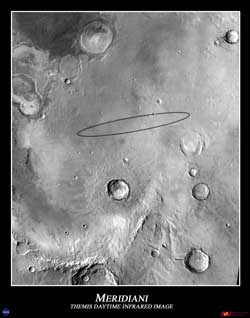
The Opportunity Landing Site at Meridiani Planum. The oval is the
expected landing area. This image was taken by the THEMIS instrument
on the Mars Odyssey spacecraft from orbit, and shows the area during
daytime in infrared wavelengths of light.
Photo Credit: NASA/JPL/ASU |