History:
 Satellite imagery consists of
photographs of Earth made by means of artificial satellites.� The first
satellite photographs of Earth were made August 14, 1959 by the US satellite Explorer 6.� In 1972 the United States started the Landsat program, the
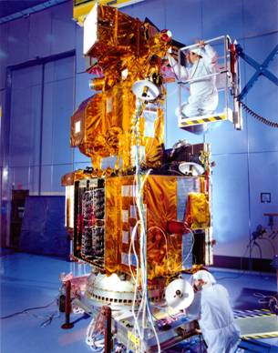
largest program for acquisition of imagery of Earth from space. Landsat 7(Image
to below), the most recent Landsat satellite, and was launched in 1999.
Satellite images have many applications in agriculture, geology, forestry,
biodiversity conservation, regional planning, education, intelligence and
warfare.�
Satellite imagery consists of
photographs of Earth made by means of artificial satellites.� The first
satellite photographs of Earth were made August 14, 1959 by the US satellite Explorer 6.� In 1972 the United States started the Landsat program, the
largest program for acquisition of imagery of Earth from space. Landsat 7(Image
to below), the most recent Landsat satellite, and was launched in 1999.
Satellite images have many applications in agriculture, geology, forestry,
biodiversity conservation, regional planning, education, intelligence and
warfare.�
NASA
The Landsat Program
The Landsat satellites were launched in 1972, 1975, 1978, 1982, 1984, failed in 1993, 1999.� The Benefits of Landsat 7 data is acquired systematically to build and periodically refresh a global archive of sun-lit, substantially cloud-free images of the Earth's landmass. Approximately one quarter of the Earth's landmass is imaged every 16 days, using a planning scenario that emphasizes seasonal changes in vegetation and uses cloud predictions from National Oceanic and Atmospheric Administration to avoid imaging cloudy areas, thus optimizing the data acquisition strategy. If the data user wants a particular image, chances are that it is already in the data archive. Also, as environmental changes occur on the Earth's surface, it is highly probable that recent prior data already exists and can be quickly retrieved to compare with newly acquired data.
Usage of these imagers:
Congress decided that land satellites could be privatized (1984 Land Remote Sensing Commercialization Act). National Oceanic and Atmospheric Administration, the agency in charge of all Landsat operations, was instructed to find a commercial vendor for Landsat data. National Oceanic and Atmospheric Administration selected Earth Observation Satellite Company.
The contract gave Earth Observation Satellite Company the responsibility for archiving, collecting and distributing current Landsat data as well as the responsibility for building, launching and operating the following two Landsat satellites (with government subsidies).
Commercialization proved troublesome, Earth Observation Satellite Company had limited commercial freedom due to provisions of the 1984 law. Given these constraints, Earth Observation Satellite Company raised image prices from $650 to $4400 and restricted redistribution. While the U.S. monopoly of Landsat-like data made this 600% increase feasible, the practice priced out many data users. (As a result, many data users migrated to the free low-resolution land data being captured by meteorological satellites.) In 1986, a French Landsat-like satellite launch broke the U.S. monopoly.
Another benefit of Landsat 7 is that data products are available from the U.S. Geological Survey's Center for Earth Resources Observation and Science, Sioux Falls, South Dakota. These products are distributed at "the Cost of Fulfilling User Requests� price. This is a significant price reduction from commercial data sales, allowing renewed use of Landsat data in academic institutions for scientific research. This has again stimulated the use of multispectral imagery in a variety of applications, fostering new uses not only for Landsat data but for other remote sensing data as well.
Shuttle Radar Topography Mission
The Shuttle Radar Topography Mission is an international research effort that obtained digital elevation models on a near-global scale from 56 �S to 60 �N, to generate the most complete high-resolution digital topographic database of Earth to date. Shuttle Radar Topography Mission consisted of a specially modified radar system that flew onboard the Space Shuttle Endeavour during the 11-day STS-99 mission in February of 2000. To acquire topographic (elevation) data, the Shuttle Radar Topography Mission payload was outfitted with two radar antennas. One antenna was located in the Shuttle's payload bay, the other on the end of a 60-meter (200-foot) mast that extended from the payload bay once the Shuttle was in space. The technique employed is known as Interferometric Synthetic Aperture Radar.
The elevation models are arranged into tiles, each covering one degree of latitude and one degree of longitude, named according to their south western corners. The resolution of the cells of the source data is one arc second, but 1" (approx. 30 meter) data have only been released over United States territory; for the rest of the world, only three arc second data (approx. 90 meter) are available. Each one arc second tile has 3,601 rows, each consisting of 3,601 16 bit bigendian cells. The dimensions of the three arc second tiles are 1201 x 1201.
The elevation models derived from the Shuttle Radar Topography Mission data are used in Geographic Information Systems. They can be downloaded freely over the internet, and their file format (.hgt) is supported by several software developments.
Google Earth also uses digital elevation
model data collected by NASA's Shuttle Radar Topography Mission. This means one
can view the Grand Canyon or Mount Everest in  three dimensions, instead of 2D like other map programs/sites. Since
November 2006, the 3D views of many mountains, including Mount Everest, have
been improved by the use of supplementary DEM data to fill the gaps in Shuttle
Radar Topography Mission coverage.
three dimensions, instead of 2D like other map programs/sites. Since
November 2006, the 3D views of many mountains, including Mount Everest, have
been improved by the use of supplementary DEM data to fill the gaps in Shuttle
Radar Topography Mission coverage.
Commercialized Satellites:
IKONOS is a commercial earth observation satellite, and was the first to collect publicly available high-resolution imagery at 1- and 4-meter resolution. It offers multispectral (MS) and panchromatic (PAN) imagery. The IKONOS launch was called in the New York Times �one of the most significant developments in the history of the space age.� IKONOS imagery began being sold on January 1, 2000. It was launch September 24, 1999.
 QuickBird is a high-resolution
commercial earth observation satellite, owned by DigitalGlobe and launched on October
18, 2001 as the first satellite in a constellation of three scheduled to be in
orbit by 2008. QuickBird collects the highest resolution commercial imagery of
Earth, and boasts the largest image size and the greatest on-board storage
capacity of any satellite. The satellite collects panchromatic (black &
white) imagery at 60-70 centimeter resolution and multispectral imagery at 2.4-
and 2.8-meter resolutions.� At this resolution, detail such as buildings and
other infrastructure are easily visible. However, this resolution is
insufficient for working with smaller objects such as a license plate on a car.
The imagery can be imported into remote sensing image processing software, as
well as into GIS packages for analysis. The imagery can also be used as a
backdrop for mapping applications, such as Google Earth and Google Maps.
QuickBird is a high-resolution
commercial earth observation satellite, owned by DigitalGlobe and launched on October
18, 2001 as the first satellite in a constellation of three scheduled to be in
orbit by 2008. QuickBird collects the highest resolution commercial imagery of
Earth, and boasts the largest image size and the greatest on-board storage
capacity of any satellite. The satellite collects panchromatic (black &
white) imagery at 60-70 centimeter resolution and multispectral imagery at 2.4-
and 2.8-meter resolutions.� At this resolution, detail such as buildings and
other infrastructure are easily visible. However, this resolution is
insufficient for working with smaller objects such as a license plate on a car.
The imagery can be imported into remote sensing image processing software, as
well as into GIS packages for analysis. The imagery can also be used as a
backdrop for mapping applications, such as Google Earth and Google Maps.
WorldView-1 is a commercial earth observation satellite owned by DigitalGlobe. It was launched September 18, 2007, and DigitalGlobe plans to launch another, similar satellite after its construction is finished in late 2008. With an average revisit time of 1.7 days, WorldView-1 is capable of collecting up to 750,000 square kilometers (290,000 square miles) per day of half-meter imagery.
The Future:
GeoEye-1 Formerly known as Orbview-5, this device is currently under construction at a General Dynamics facility near Phoenix, Arizona. It is due to be launched in early 2008. It will provide 41 cm panchromatic and 1.65 meter multispectral imagery in 15.2km swaths.
Other Satellites:
In 1977, the first real time satellite imagery was acquired by the USA's KH-11 satellite system. The KH-11, also referenced by the codenames 1010, Crystal and Kennan, also commonly known as "Key Hole", was a type of reconnaissance satellite launched by the American National Reconnaissance Office between December 1976 and 1990 and used until present. Manufactured by Lockheed in Sunnyvale, California, the KH-11 was the first American spy satellite to utilize electro-optical digital imaging, and create a real-time optical observation capability.� Since this KH-12�s and KH13�s have been launched.