LiDAR Data
LiDAR stands for Light Detection and Ranging. It’s like radar, except with laser light instead of
sound. Flown from a helicopter or fixed wing aircraft, laser pulses are
sent to the ground and their reflections back are recorded. Accurate
distances are then calculated to the points on the ground and elevations can be
determined along with the ground surface buildings, roads, and vegetation can
be recorded. These elevations are combined with digital
aerial photography to produce a digital elevation model of the earth.
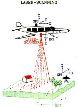 A LiDAR sensor may be
mounted on-board an aircraft or helicopter. Once in flight, the aircraft
travels over the terrain at speeds of 60 meters per second. During the flight,
the LiDAR sensor pulses a high frequency laser beam toward the earth through an
opening in the bottom of the aircraft. The LiDAR sensor records the time
difference between the pulses of the laser beam and the return of the reflected
laser signal to the aircraft.
A LiDAR sensor may be
mounted on-board an aircraft or helicopter. Once in flight, the aircraft
travels over the terrain at speeds of 60 meters per second. During the flight,
the LiDAR sensor pulses a high frequency laser beam toward the earth through an
opening in the bottom of the aircraft. The LiDAR sensor records the time
difference between the pulses of the laser beam and the return of the reflected
laser signal to the aircraft.
The LiDAR transceiver itself doesn’t move
but, a scan mirror assembly is mounted beneath the transceiver. A 45-degree
folding mirror reflects the laser pulses onto a moving mirror which directs the
laser pulses to the earth. The reflected laser light from the ground follows
the reverse optical path and is directed into a small telescope. The moving
mirror produces a conical sampling pattern beneath the aircraft over a
30-degree wide swath, permitting the collection of topographic information over
a strip approximately 300 meters in width from the nominal 600 meter data
collection altitude.
 The LiDAR instrument only
collects elevation data and along with the data a GPS unit and Inertial
Measuring Unit is placed with the aircraft. This is done so because as the
LiDAR sensor collects data points, the location of the data is recorded along
with the GPS sensor. Data is
required to process the return time for each pulse returned back to the sensor
and calculate the variable distances from the sensor, or changes in land cover
surfaces. After the flight, the data are downloaded and
processed using specially designed computer software. The end product is
accurate, geographically registered longitude, latitude, and elevation or the
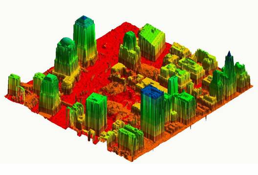
x, y, and z positions for every data point. LiDAR mapping data are composed of
elevation measurements of the surface and are acquired through aerial
topographic surveys. The file format used to capture and store LiDAR data is a
simple text file and referred to as "x, y, and z," where x is
longitude, y is latitude, and z is elevation. Using the elevation
"points," LiDAR data may be used to create detailed topographic maps.
With these data points they allow the generation of a digital elevation model
of the ground surface
The LiDAR instrument only
collects elevation data and along with the data a GPS unit and Inertial
Measuring Unit is placed with the aircraft. This is done so because as the
LiDAR sensor collects data points, the location of the data is recorded along
with the GPS sensor. Data is
required to process the return time for each pulse returned back to the sensor
and calculate the variable distances from the sensor, or changes in land cover
surfaces. After the flight, the data are downloaded and
processed using specially designed computer software. The end product is
accurate, geographically registered longitude, latitude, and elevation or the
x, y, and z positions for every data point. LiDAR mapping data are composed of
elevation measurements of the surface and are acquired through aerial
topographic surveys. The file format used to capture and store LiDAR data is a
simple text file and referred to as "x, y, and z," where x is
longitude, y is latitude, and z is elevation. Using the elevation
"points," LiDAR data may be used to create detailed topographic maps.
With these data points they allow the generation of a digital elevation model
of the ground surface
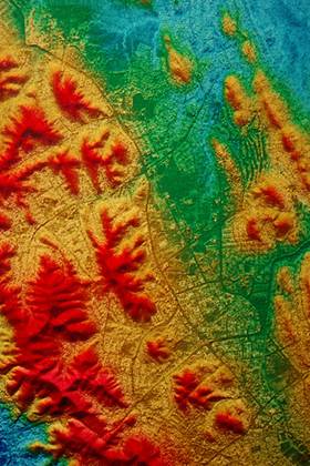
 The LiDAR data is read
trough a color value coordinated map of the different elevations of the
terrain. With this system various
surface elevations can be viewed in distinct color formations corresponding to
an elevation scale giving a three dimensional view of the terrain. The advantages of using LiDAR, instead of
other traditional means for topographic mapping, is that LiDAR technology
offers the opportunity to collect terrain data of steep slopes and shadowed
areas that are initially dangerous or inaccessible.
The LiDAR data is read
trough a color value coordinated map of the different elevations of the
terrain. With this system various
surface elevations can be viewed in distinct color formations corresponding to
an elevation scale giving a three dimensional view of the terrain. The advantages of using LiDAR, instead of
other traditional means for topographic mapping, is that LiDAR technology
offers the opportunity to collect terrain data of steep slopes and shadowed
areas that are initially dangerous or inaccessible.