
SURVEYING is the technique and science of accurately determining
the terrestrial or three-dimensional space position of points and the distances
and angles between them. These points are usually, but not exclusively,
associated with positions on the surface of the Earth, and are often used to
establish land maps and boundaries for ownership or governmental purposes.
Even though remote sensing has greatly speeded up the process of gathering
information, and has allowed greater accuracy control over long distances, the
direct survey still provides the basic control points and framework for all
topographic work, whether manual or GIS-based.
In areas where there has been an extensive direct survey and mapping
program (most of Europe and the Continental
The original American topographic surveys (or the British
"Ordnance" surveys) involved not only recording of relief, but
identification of landmark features and vegetative land cover.
HISTORY
Surveying techniques have existed throughout much of recorded history. In
ancient
� The
Egyptian land register (3000 BC).
� Under
the Romans, land surveyors were established as a profession, and they
established the basic measurements under which the empire was divided, such as
a tax register of conquered lands (300 AD).
� In
�  covered all
� contained names of the land owners, area, land quality, and
specific information of the area's content and habitants.
� did not
include maps showing exact locations
� Continental
� contained
numbers of the parcels of land (or just land), land usage, names etc., and
value of the land
� 100
million parcels of land, triangle survey, measurable survey, map scale: 1:2500 and
1:1250
� spread fast around Europe, but faced problems especially in
Mediterranean countries, Balkan, and Eastern
� A
cadastre loses its value if register and maps are not constantly updated.
� Large-scale
surveys are a necessary pre-requisite to map-making. In the late 1780s, a team
from the Ordnance Survey of

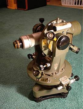
A theodolite is an instrument for measuring both horizontal and
vertical angles, as used in triangulation networks. It is a key tool in surveying
and engineering work, but theodolites have been adapted for other specialized
purposes in fields like meteorology and rocket launch technology. A modern
theodolite consists of a telescope mounted movably within two perpendicular
axes, the horizontal or trunnion axis, and the vertical axis. When the
telescope is pointed at a desired object, the angle of each of these axes can
be measured with great precision, typically on the scale of arcseconds.
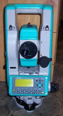
A total station is an optical instrument used in modern surveying as
well as by police, crime scene investigators, private accident
reconstructionists and insurance companies to take measurements of scenes. It
is a combination of an electronic theodolite (transit), an electronic distance
measuring device (EDM) and software running on an external computer.
The gyrotheodolite is used when the north-south reference bearing of
the meridian is required in the absence of astronomical star sights. This
mainly occurs in the underground mining industry and in tunnel engineering. For
example, where a conduit must pass under a river, a vertical shaft on each side
of the river might be connected by a horizontal tunnel. A gyrotheodolite
can be operated at the surface 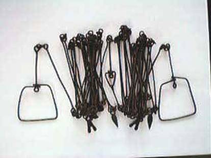 and then again at the
foot of the shafts to identify the directions needed to tunnel between the base of the two shafts. Unlike an artificial horizon or
inertial navigation system, a gyrotheodolite cannot be relocated while it is operating. It must be
restarted again
and then again at the
foot of the shafts to identify the directions needed to tunnel between the base of the two shafts. Unlike an artificial horizon or
inertial navigation system, a gyrotheodolite cannot be relocated while it is operating. It must be
restarted again  at each site.
Chains and Tapes were also traditionally used to measure distances in land
surveys.� These can still be used today
for small short distance surveying, while most distancing is done with laser distance
finders today.
LINKS
http://en.wikipedia.org/wiki/Surveying
http://en.wikipedia.org/wiki/Total_station
http://en.wikipedia.org/wiki/Theodolite